Action A1: Innovative devices construction
In the framework of this actions the following were delivered:
- LIDAR devices-technically validated and calibrated for the measurements of CO2, CH4 and N2O
- IoT devices for the agricultural machinery of the pilot farmers
- Meteorological stations and photovoltaic systems
- Multispectral cameras for the determination to be used for the determination of Soil Organic Carbon stock changes
Action C2: Technology for SOC stock changes measurement
Deliverable-Report on the Soil Organic Carbon related baseline conditions of the pilot fields
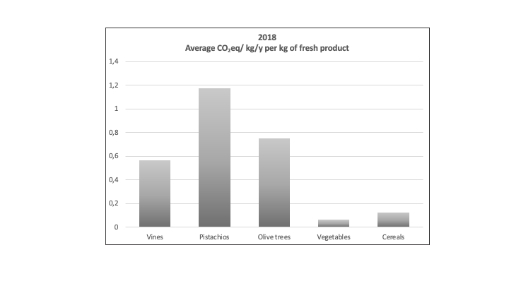
Summary: The objective of this deliverable is to provide support to the development of the methodology for SOC stock measurements and also to illustrate the current situation of the pilot fields of the project, in terms of agricultural practices, consumptions etc. For illustrating the initial condition (background) of each pilot field, soil samples were collected. In specific, composite samples were collected at 30 cm depth intervals (i.e., 0-30 and 30-60 where possible) and analyzed. In addition, all field data for 2018 was collected after interviewing with farmers, by filling in specifically developed questionnaires and face-to-face discussions.All the above data was evaluated and processed in order to assess the practices that contribute to SOC loss and GHGs emissions. For this, data for past land use, fuels consumption, tillage practices, machinery used, labor requirements, burning of residuals and wastes, fertilization/irrigation practices, water consumption, weed and pests control, waste management practices, composting or recycling at field, and others, was collected and assessed.
The study estimated also the GHGs emissions using the Tier 1 and 2 approaches and by using the equations of IPCC (2006), in order to figure out the baseline and also define the hot spots of GHGs emissions.
Action C3: Telemetry
Deliverable-Manual of the Data Logger and the developed APIs
Summary: The team of ClimaMED project has developed an effective telemetric system, which satisfies the need for seamless collection and transfer of data from different sources in an effective manner. Its effectiveness could be evaluated against the criteria of: (i) easy to be installed, (ii) easy to use, (iii) minimum requirements for maintenance, (iv) extensibility and connectivity, (v) interoperability, and (vi) cost of operation.
The IoT Telemetry System supports data reception and management (on cloud), visualization of data and reporting generation. It also includes a web App for interfacing with the users as well as a set of APIs for exchanging data with third parties’ systems. An integrated telemetric network was implemented bringing together various IoT technologies, namely meteorological and other sensor devices, devices attached on farm equipment, multispectral cameras and LIDAR systems. The telemetry network is the point of gathering, pre-processing and transmitting data and events from all connected devices through the usage of the appropriate APIs. These APIs will have dual roles. The first one will be the provision of access to data that it’s acquired by the devices and the second one will be the management of the devices, supporting simultaneously the monitoring and the configuration of connected devices.